StereoCAD

For StereoCAD users · October 2026 release

From stereo restitution
to the complete system.

StereoCAD changes profile: from stereo drawing software to a complete, automatic system that goes from the raw dataset to the cartographic deliverables.

Version 1.4.13 · November 2026

What is new
in 1.4.13.

Image orientation: stronger ground control, whole images, lenses taken into account, results that start from what succeeded.

Ground control points lead the block

Until 1.4.12
Measured points and GNSS shared the block
From 1.4.13
With measured points, the block follows them

The residuals on the points go down. Without points the reference stays the GNSS. The box Ground points rule the block starts checked.
Full resolution

Until 1.4.12
Tie points were searched on reduced images
From 1.4.13
On the whole images, enormous ones in tiles

Orientation takes longer. A reduction can still be asked for in Advanced.

Strongly distorting lenses

Until 1.4.12
The corners of the photos could get lost
From 1.4.13
Image pairs are verified with the lens

On DJI drones the start is the factory calibration written in the images.

Images not oriented

Until 1.4.12
No command to leave them out
From 1.4.13
Exclude them from the result and run again

Readmit them brings them back.

Ground control points and coordinates

Until 1.4.12
A point could not be switched off
From 1.4.13
Disable, enable again or delete it with its measurements

A new project no longer inherits the files of the previous one, and a coordinate file with no measurements no longer comes back on its own to block Start.

Clear results

Until 1.4.12
Successes and what was missing mixed together
From 1.4.13
First what succeeded, at the end what to do

Every result ends with what to address, each with the thing to do.

Version 1.4.12 · November 2026

What is new
in 1.4.12.

Drone flights with nadir and oblique images, from the navigation surface to the ground control points.

Navigation surface on drone images

Until 1.4.11
On low flights with smaller images it could come out empty
From 1.4.12
Measured, and an empty one already saved is made again

The stereo and the mark always have a reference elevation.

More reliable ground control points

Until 1.4.11
With strongly distorting lenses, images that do not see the point were proposed
From 1.4.12
Only the images that really see it

From Pix4D projects the ground control points come in by themselves, with their measurements on the images.

Flights on the diagonal

Until 1.4.11
Without a cloud, the view stayed empty with the stereo on
From 1.4.12
The mosaic and, from near, the real photograph

Visit point, the Overview, continuous roaming and the + and - keys work here too.

Map and Rotation

Until 1.4.11
The navigation map could not be switched off
From 1.4.12
Two buttons under Show

Rotation brings back the view from above turned like the stereo, keeping the scale and the mark.

A more faithful map

Until 1.4.11
Wavy edges and stretched houses at the margins
From 1.4.12
Straight edges stay straight

The mosaic and the photographs use the nadir images only, on a smoothed surface. The mark's elevation does not change.

A cleaner dense cloud

Until 1.4.11
In Terrain and buildings, 45-degree obliques got in too
From 1.4.12
Nadir images only, in less time

The count and the time estimate say so before it starts.

Auto Z, rubber band, Esc

Until the first 1.4.12
Automatic elevation from menu and keys only
Now
An Auto Z button on the Stereo bar

The rubber band ends on the centre of the mark and Esc holds the stereo on flights on the diagonal too. Point clouds are no longer imported: work on clouds belongs to StereoCloud3D.

Version 1.4.11 · November 2026

What is new
in 1.4.11.

A large stereo and a plan you can read from near, with the checks and exports surveyors asked for.

A large stereo from the start

Until 1.4.10
With the plan on the whole block, a tiny model in the middle of the screen
From 1.4.11
The two images fill the stereo screen

The wheel enlarges from the first notch, and the keypad's + and - zoom by two at a time, also when looking only into the stereo.

The real photograph under the plan

Until 1.4.10
From near, a blurred mosaic or the cloud's scattered points
From 1.4.11
From near, the photograph, as sharp as the stereo

No computing and no waiting: the plan uses the same images as the stereo, laid on the navigation surface.

Visit point where you are

Until 1.4.10
The mark followed the mouse to the button
From 1.4.11
Ctrl+G holds the mark until Go or Enter

The fields take the point where you are, so the hand can reach the window without moving it.

Checking ground control points

Until 1.4.10
Coordinates seen one at a time, decimal commas misread
From 1.4.11
X, Y, Z in the list, and the offset from the orientation

On an imported orientation too, with no new triangulation. Lists with a decimal comma, or North before East, are read correctly.

A block in several folders

Until 1.4.10
Only the fullest folder of images was taken
From 1.4.11
Every folder, listed with a tick

Nadir and obliques in one project, and with BINGO a camera per folder. Stereo pairs keep nadir and oblique images apart.

The DTM for CAD

Until 1.4.10
Contours only
From 1.4.11
DXF with 3D faces or points, and GeoTIFF

From the DTM row of the dense cloud panel, at the grid step you choose.

Version 1.4.10 · November 2026

What is new
in 1.4.10.

No more getting lost on the model, also for who comes from the old StereoCAD64.

Navigation surface always ready

Until 1.4.9
Made in the background, the plan could stay black
From 1.4.10
The opening waits for it, with a progress bar

On every project, those made earlier too: the surface and its photographs are ready before you start working, and before the stereo starts.

An Overview that answers

Until 1.4.9
A double click, with the stereo running
From 1.4.10
A click, with the stereo on or off

Held down, the plan and the stereo follow the mouse. The map shows the photographs and the ground control points, and back on the plan the mark stays where it was taken.

Visit point and ground control points

Until 1.4.9
No way to type where to go
From 1.4.10
Coordinates or a point from the list, at 1:1

Ctrl+G takes the plan and the stereo to the point, with the stereo off too.

Continuous roaming

Until 1.4.9
The stereo stopped at the plan's edge
From 1.4.10
F10: the mouse has no edges

You can look only into the stereo, as in StereoCAD64; what you need to know is said inside the stereo itself.

Version 1.4.9 · November 2026

What is new
in 1.4.9.

Right heights even when the GNSS of the images and the ground control points disagree.

GNSS weights checked on the ground points

Until 1.4.8
GNSS weighed by its own residuals
From 1.4.9
Checked against the control points

When the control points are off by more than twice their accuracy, the GNSS was weighed too much: the program widens it by itself and adjusts again. On 224 images with 44 check points the height error went from 9.1 to 3.3 cm; with a good GNSS nothing changes.

Triangulation choices

Until 1.4.8
Those of the active orientation
From 1.4.9
Those of the last triangulation

Image orientation reopens with the choices of the last run, also when its block was not imported: a box turned off no longer comes back on.

Images without tie points

Until 1.4.8
Could make the import refuse the block
From 1.4.9
Left out and named in the report

An image left without tie points after the adjustment is no longer written as oriented.

Version 1.4.8 · November 2026

What is new
in 1.4.8.

What your ground control points are really worth, and the images the triangulation leaves out brought back.

Cross-validation of the ground points

Until 1.4.7
Residuals of the points used
From 1.4.8
The real error beside them

Each ground control point is left out in turn and measured by the block adjusted without it: the real error where there are no points, beside the residuals of the control and check points.

Ground points rule the block

Until 1.4.7
Points and GNSS by their accuracy
From 1.4.8
Optional: points at 5 mm, GNSS at 10 m

As other programs do: the residuals on the points go near zero, and the cross-validation says the real error. It helps when GNSS and points disagree; run both and keep the lower cross-validation.

Images left out

Until 1.4.7
Left out
From 1.4.8
Deep recovery offered

When the triangulation leaves out images with GNSS, the result says so with the extra time and searches them again with the calibrated camera at a click.

Ground points after Import images

Until 1.4.7
Could close the program
From 1.4.8
Corrected

With the ground control points window open, importing a block with fewer images could close the program.

Version 1.4.7 · November 2026

What is new
in 1.4.7.

A steady 3D view with large dense clouds, and a stereo you can tell apart at a glance.

Dense cloud in the 3D view

Until 1.4.6
Could close with large clouds
From 1.4.7
Steady while the cloud loads

With large dense clouds the program could close while it loaded a new piece of the cloud in the 3D view. Corrected.

Stereo bar

Until 1.4.6
Like the other bars
From 1.4.7
On a blue band labelled Stereo

The stereo bar stands out from the others, so it is found at once.

3D window closed

Until 1.4.6
Ignored
From 1.4.7
Stereo off, with a message

If the 3D window is closed from the Windows taskbar or with Alt+F4, stereo turns off and a message says why, as in StereoCloud3D.

Version 1.4.6 · October 2026

What is new
in 1.4.6.

A 3D window you can resize, a Stereo menu in order, and a triangulation that no longer falls over on big photos or mixed heights.

Resizable 3D window

Until 1.4.5
Always full screen
From 1.4.6
A normal window, with quad-buffer

Stereo › Stereo monitor › Resizable 3D window: with quad-buffer stereo the 3D window and the main window move and resize like any other. Off by default.

Stereo menu in order

Until 1.4.5
Every option in one list
From 1.4.6
Everyday commands first

The first line says whether stereo is on and on which monitor; layouts and checks are in two submenus, as in StereoCloud3D.

Triangulation at full resolution

Until 1.4.5
Could run out of memory
From 1.4.6
As many photos as the memory holds

Photos are worked together only as far as the free memory allows; a photo that still does not fit is lost alone and the calculation goes on.

Mixed heights detected

Until 1.4.5
Wrong heights far from the points
From 1.4.6
Sea level or ellipsoid, chosen

The GNSS heights of the images can be declared on the ellipsoid and brought to sea level with the geoid; the report warns when the focal length drifts, the usual sign of mixed heights.

Version 1.4.5 · October 2026

What is new
in 1.4.5.

Photos the triangulation used to leave out come back, ground points are easier to read, and StereoCAD64 projects open from the File menu.

Photos recovered in the triangulation

Until 1.4.4
Left out of the block
From 1.4.5
Brought back before the adjustment

A strip not joined to the next is oriented on its own GNSS; a single photo starts from its ground points or GNSS. A photo that would land far from its GNSS is refused, and the report says which ones came back.

Ground points

Until 1.4.4
Zoom only, numbers apart
From 1.4.5
Drag the crop, names on the marks

In the point window the crop moves by dragging with the right or middle button; every point nearby shows its name next to its mark, without overlapping.

StereoCAD64 projects

Until 1.4.4
Through New project
From 1.4.5
File › Open StereoCAD64 project

The .scad file opens as a new project with images, orientations and drawing; the original is not changed. The same button is on the welcome screen.

Import and coding

Until 1.4.4
Previews taken for photos
From 1.4.5
The photos at camera size

Previews with the same names as the photos are told apart, code tables in text format load as libraries, and the right button in the 3D view gives the properties of a drawn line.

Version 1.4.4 · October 2026

What is new
in 1.4.4.

Drawing driven by the stereo with no edge, ECW images and Metashape projects in degrees read as they come, and support one click away.

Drawing follows the stereo

Until 1.4.3
At the edge the stereo lagged
From 1.4.4
The model slides under the mark

During a drawing command the mouse moves the mark and the plan follows with no edge, also in the 3D view; the click takes the mark's exact point. F8 switches it off.

ECW images

Until 1.4.3
To be converted elsewhere
From 1.4.4
Read at the import

At the import and in the triangulation the ECW images are converted once into TIFF in the project, with a progress bar.

Metashape projects in degrees

Until 1.4.3
Refused
From 1.4.4
Into the project's system

A Metashape XML in WGS84, usual for drone flights, goes into the StereoCAD project's system with its markers, heights brought above the sea.

Share with support

Until 1.4.3
The log found by hand
From 1.4.4
One zip from the Help menu

A picture of the window, the log and your comment in one file to attach to an e-mail. After a crash StereoCAD asks whether to send the report to MENCI Engineering. In Stereo AI, Copy under every answer.

Version 1.4.3 · October 2026

What is new
in 1.4.3.

Plan, Overview and stereo that always agree, a photo background in seconds, and calm water that stays flat in the dense cloud.

Plan, Overview and stereo in step

Until 1.4.2
The pair could jump back and forth
From 1.4.3
One rule for the pair

The mark never stays behind; a short pause on the Overview hands it the stereo, and the status bar says why the mark stops where no pair sees the ground.

1:1 zoom

Until 1.4.2
Free steps only
From 1.4.3
Ctrl+1, steps through 1:1

From the keyboard, the status bar or Stereo > View; the chosen zoom stays when the pair or the height change.

Navigation surface with the photos

Until 1.4.2
Dense cloud started on opening
From 1.4.3
Light surface in a few seconds

On opening, a light surface measured on reduced photos, with a mosaic of the photos as plan background; the dense cloud is made only when you ask for it.

Flat water in the dense cloud and the DSM

Until 1.4.2
Holes metres deep on calm water
From 1.4.3
Flat at the water level

Marshes, ponds and canals become flat at their measured level, with points marked as water (class 9). Optionally Stereo AI looks at a reduced mosaic of the photos and says where the water is: nothing is flattened in a town.

Version 1.4.2 · October 2026

What is new
in 1.4.2.

The free zone of the mark sized to the way you work, and a log that says which graphics card draws.

Free zone of the mark

Until 1.4.1
Fixed at half the plan
From 1.4.2
From 30% to 90%

Stereo > View > Free zone size: larger, the plan scrolls only near its edges. Saved in the project; the Scroll button still switches it off.

Graphics card in the log

Until 1.4.1
Not written
From 1.4.2
Written at start

The log says which card draws the program and, when it is the integrated one of the processor, what to do to use the dedicated card.

Version 1.4.1 · October 2026

What is new
in 1.4.1.

Orientations from your own table, one more satellite read without its RPC, a way to have the others added, and a fix.

Camera typed by hand

Until 1.4.0
A .bcc camera file needed
From 1.4.1
Focal length and pixel

In the BINGO / OPK import, the focal length and the pixel from the camera's data sheet: the image size is read from the images.

Orientations from your own table

Until 1.4.0
Rewritten by hand
From 1.4.1
Written by Stereo AI

Columns in any order, decimal comma, gon or radians: Stereo AI shows a preview, and after your yes writes the file and fills the Import window. The program copies the numbers.

ALOS PRISM

Until 1.4.0
Recognised, not imported
From 1.4.1
Read from its rigorous model

Level 1B1 views in JAXA's CEOS format: the four detector strips of each view become one straightened image.

Deliveries not read yet

Until 1.4.0
Orbit and attitude only: not imported
From 1.4.1
A sample for MENCI Engineering

With your consent, only the metadata files leave, never the images; the next version reads that satellite.

Contour labels

Until 1.4.0
Could close the program
From 1.4.1
Fixed

The labels of contour lines no longer close StereoCAD.

Version 1.4.0 · October 2026

What is new
in 1.4.0.

Free Stereo AI at hand in every window, satellites read with the rigorous model, the accuracy report inside the program and a clear license agreement.

License agreement

Until 1.3.1
You activated the key
From 1.4.0
At the first activation you read and accept the EULA, once

The text can be read again from Help › License status and on this site, with the license and maintenance contract.

Fee not renewed

Before
Without renewal the license expired
From 1.4.0
12 months of read-only use

You open and look at your projects, without changing, saving, exporting or printing them. Renew with the new year's fee and the same key returns to full use.

Ask Stereo AI

Until 1.3.1
From the menu bar
From 1.4.0
Free, also from the main windows

Its answers use no AI credits. Every main window opens the assistant with a question about that window already written: complete it and send it.

What the project allows

Until 1.3.1
You chose where to start
From 1.4.0
Stereo AI proposes the possible work

When a project opens, Stereo AI looks at the data in its folder and proposes the work it allows, with the reason and the products; a click opens the command.

Satellite data

Until 1.3.1
The RPC formats the program knew
From 1.4.0
Sensor library and rigorous model

A new format is learnt from the delivery's documents or from the supplier's public documentation, and checked on the scene. Pléiades, SPOT 6/7 and SpaceEye-T also without RPC; tiled Pléiades as one scene.

Accuracy

Until 1.3.1
Comparisons outside the program
From 1.4.0
Reference and accuracy report

A laser survey or another DSM is imported as a reference and compared with the project's DSMs: spread, offset, plan shift, difference map and a report for the client.

Satellite pairs

Until 1.3.1
The nearest scenes
From 1.4.0
Scenes with a good stereo base

Each scene is paired with the one that gives the right depth, not with a view of the same pass.

First start

Until 1.3.1
Toolbars could cover buttons
From 1.4.0
Everything in place, also at 1366×768

At the first start toolbars and windows do not cover buttons, the plan view or the right column, and stay on the screen.

Languages

Until 1.3.1
License states as server codes, in English
From 1.4.0
In the interface language

License status and messages in six languages; the Stereo AI window also in French, German and Spanish.

The changes

Six points,
before and now.

Role of the software

Until the previous version
Stereo drawing and generation of map databases
From the October 2026 release
A complete system, from the raw dataset to the final deliverables

You load the dataset and the system takes it to the deliverables fully automatically, with stereo control at every stage.

Input dataset

Until the previous version
Already oriented by third parties
From the October 2026 release
Supplied by the client as it is, recognised automatically

StereoCAD recognises everything the client supplies: images, accessory files, metadata, previous orientations, calibration certificates, control points and any other information useful for aerial mapping.

Orientation and adjustment

Until the previous version
Outside the software
From the October 2026 release
Inside: rigorous aerial triangulation or bundle adjustment with self-calibration

The software evaluates the dataset and proposes the best solution for the best result with the information available. You choose the target; the system adjusts the dataset.

Outputs

Until the previous version
Restitution and map databases
From the October 2026 release
Point cloud, DSM, DTM, contour lines, 3D mesh, true orthophoto, plus restitution

On the adjusted dataset the system proposes the possible outputs. The DSM is derived from the point cloud, and so are the DTM and the contour lines. The true orthophoto needs no mosaicking and no stitching.

Image types

Until the previous version
Aerial photogrammetry
From the October 2026 release
Conventional aerial photogrammetry, drone, terrestrial photography

The 3D mesh model of the surveyed object comes from conventional aerial photogrammetry, drone or terrestrial photography.

Stereo

Until the previous version
The main working tool
From the October 2026 release
Kept at the highest level, also for checking and acceptance

Every result can be checked and accepted in stereo.

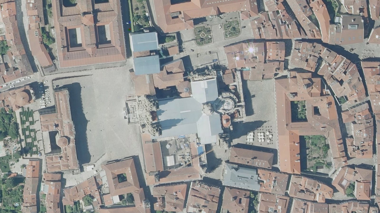
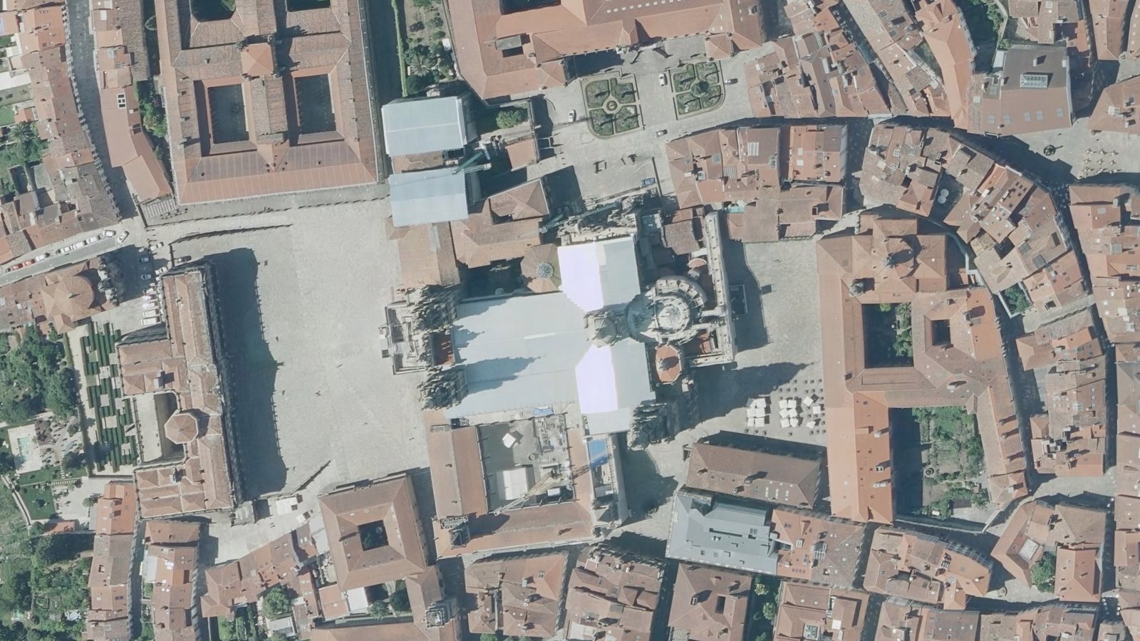
Santiago de Compostela cathedral seen by the left eye The same cathedral seen by the right eye
Obra derivada de PNOA 2020 CC-BY 4.0 scne.es

What stays

Everything you knew
stays.

Automation does not replace stereoscopy: restitution stays at the highest level possible, in an extremely powerful drawing environment, built for the most demanding stereo operators.

Datasets already oriented by others still go straight to stereo, as before.

Stereo now has two roles

  • RestitutionThe tool you draw with, as before.
  • Check and acceptanceThe tool for checking, verifying and accepting the results produced automatically.

What is added

The automatic workflow

  1. Dataset
  2. Analysis
  3. Target
  4. Adjustment
  5. Outputs

06 Stereo control — under every step

How each step works →

Already a customer? Update, or see it on your own data.